Research
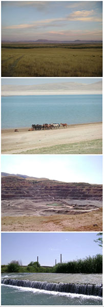 The research and field data collection of this project focusses on South Kazakhstan. This region is characterised by a very steep gradient between the snow-covered and glaciated peaks of the Tian Shan Mountains, locally reaching up to almost 5000 metres, and the flat steppe environment. The mountain piedmont area is vulnerable to various natural hazards but especially to catastrophic flooding by extensive snowmelt in spring, Alpine lake outbursts, convective rainstorms in summer, and hydrodam failures. The downstream ends of the river systems that originate in the Tian Shan periodically experience a deficit in water availability in the steppe region, caused by hydroclimatic variability and since the Soviet period by an intensification of water extraction from river systems for irrigation, industrial use, and consumption. In the semi-nomadic period, before permanent settlement, local communities were mobile and probably adapted quickly to changes in water availability by migrating up and downstream of the river systems that are the 'green corridors' in the region and in the past an important part of the Silk Road trading system. However, permanent settlement has made especially the population in downstream regions of rivers less resilient and more vulnerable to droughts, which are in this region expected to occur more frequently in the near future by climate change. In addition water quality in downstream regions is affected by industrial activity that is concentrated on the northern slopes of the Tian Shan Mountains (e.g., Almaty, Shymkent, Taraz). Kazakhstan is one of the fastest developing economies in the world and among the leaders in the production of many metals and minerals. The downside of this rapid development may be contamination of local river systems and the depletion of (ground)water resources.
Case studies
The catchment areas of the two largest river systems of the region, the Syrdarya and the Ili rivers, were selected to investigate the possible effects of climate change and human impact on water resources. These are both transnational river systems draining a large part of Central Asia with a length of respectively 2212 and 1439 km and catchment areas of 402,760 and 140,000 km2. As study of these basins as a whole is not possible within the timeframe and budget of the Newton-al Farabi project, the focus was on smaller tributary systems located within the national borders of the Republic of Kazakhstan.
The Arys river has a length of 378 km and flows from the Talas Alatau ridge and drains into the Syrdarya river near the famous archaeological site of Otrar (birthplace of Al-Farabi, c. AD 872). This region, especially around the city of Shymkent, is heavily industrialised and well-known for its lead production and smelting since the Soviet period. The effects of industrial development, dense population, and agricultural activities on water availability and quality have not been investigated systematically. Next, there seems to be a conflict of interest between the various end-users of the fairly limited water supply, which puts the downstream agricultural population at risk of drought. The Arys river has an average flow of c. 47 m3, but can experience low-flow periods during summer when it occasionally ran dry in the past. 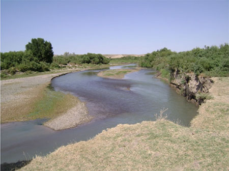 Contrastingly, during spring extensive snow melt triggers large floods, which not only cause damage to property and threatens lives, it is also suspected to be a major mechanism of dispersal of contaminant to downstream regions (and finally into the Syrdarya). Floodplain sediments may therefore be an unsuspected secondary source of contaminants, which contribute to the contamination of agricultural lands and introduction of harmful elements in the food chain by animal grazing, crop irrigation and by use for drinking water. During targeted field campaigns, the experts of various research institutes will collect river sediment samples along the fluvial corridor from upstream to downstream regions to investigate the concentration and dispersal of contaminants. This information will be coupled with advanced flood risk modelling to generate hazard maps that can be used to update existing water resources policies in the region. To address the possible effects of climate change on water availability, river discharge and meteorological series of the last century will be compared with information from tree-rings in the upstream part of the catchment and geomorphological information that indicates periods of major changes in the river systems. These studies provide an insight in the effects of hydroclimatic variability on river discharges (both low flows and extreme floods), which can be used to make current water resources policies 'climate-proof'. Moreover, the integrated approach showcased for the Arys basin can serve as a guide for deploying evidence-based water resources policies in the wider region, which can be achieved with the skill-development of early career Kazakh experts that collaborate in this project.
In the Ili-Balkash region (roughly located between Lake Balkash, the former Kazakh capital of Almaty, and the Kazakh-China border), there are numerous accounts of catastrophic flooding in the last decade. The triggering conditions for these events range from failures of Alpine lakes, blocked by landslides or old moraine ridges, to convective rainstorm in summer and the poor maintenance of hydraulic structures.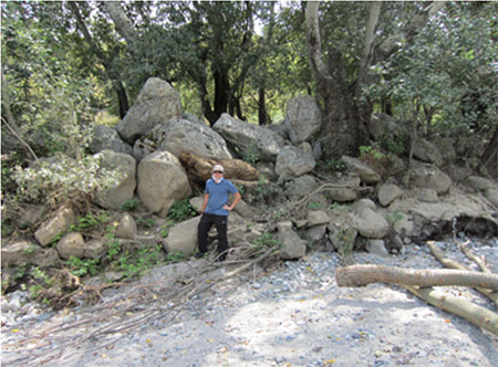 So also in flood risk management there seems to be a complicated multi-facetted situation with both natural and human factors influencing the safety of the local population. In the scope of this project, existing data and historical records on the timing and causes of catastrophic floods will be compiled and compared with geomorphologic and biologic evidence for the occurrence of similar events in the past. Several river catchments in the Tian Shan mountains (Almaty region) will be targeted for boulder-berm deposits. These boulders deposited and aligned in rows on the flanks of the incised river bed are the relic of extreme events which forced their transport. Dating of such events will be achieved with lichenometry, which allows us to extend regional flood histories with several centuries. This information will be combined with tree-ring information to detect hydroclimatic trends owed to climate change and provides an answer if recent catastrophic events are larger and more frequent than events of the past. This also allows to separate natural variability in floods from the human factor, which is necessary to be able to draft fitting flood risk policies and to take the right actions to mitigate hazards. In the main trunk valley of the Ili river we plan to collect additional sedimentary samples to date major changes in geomorphology related to long-term trends in climate change and sediment samples to measure the concentration and dispersion of contaminants that arrive from China. It is expected that China will intensify industrial and agricultural use of Ili water in the coming decades, which may greatly affect downstream regions in Kazakhstan. Especially Lake Balkash is threatened with salinification if the discharge of the Ili diminishes. Our project would provide useful information to assess future flows of the Ili and the assessment of water and sediment quality in the downstream part of the basin.