Greenland Ice Sheet more sensitive to climate change
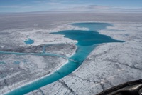
Lakes on the surface of the ice before drainage Image: Sam Doyle
30 September 2014
A study using novel field measurements to guide a numerical model finds that the Greenland Ice Sheet is more sensitive to climate change than previously thought.
The state-of-the-art 3D ice sheet model developed by researchers at the University of Cambridge and constrained by detailed field measurements taken on the ice sheet by Aberystwyth University reveals that despite its apparent stability, the massive ice sheet covering most of Greenland is more sensitive to climate change than earlier estimates have suggested, which would accelerate the rising sea levels that threaten coastal communities worldwide.
In addition to assessing the impact of the increasing levels of meltwater created and spilled into the ocean each year as the climate continues to warm, the new model also takes into account the role that soft, deforming-sediments beneath the ice sheet play in regulating its flow and stability.
The full study, Sensitive response of the Greenland Ice Sheet to surface melt drainage over a soft bed, was published in the journal Nature Communications on Monday 29 September.
The Greenland Ice Sheet, which is the second-largest ice sheet in the world, covers 1.7 million square kilometres - an area roughly eight times the size of the United Kingdom - and contains enough ice to raise sea levels by more than seven metres if it were to be lost altogether.
Currently, due to surface melting alone, it is losing ice at a net annual rate of over 200 cubic kilometers, equating to 0.6 millimetres of global sea level rise.
A similarly large, but ultimately more uncertain source of sea level rise is tied to the ice loss caused by increased flow of the ice sheet, which results in more ice being discharged into the ocean. Globally, sea levels are rising at three millimetres annually.
Large ice sheets such as in Greenland are far from stationary. Different parts of the ice often move at different speeds, causing ice to slide and deform like honey, a phenomenon known as ice flow.
Whereas other models of the Greenland Ice Sheet typically assume the ice slides over hard and impermeable bedrock - an assumption which is largely based on lack of data and observations - this study incorporates new evidence from ground-based surveys led by Aberystwyth University, which show soft and porous sediments at the bed of the ice sheet, more like the soft and muddy bottom of a lake than a sheet of solid rock.
The new study specifically identifies the intake and storage of meltwater by weak sediment beneath the ice sheet as a crucial process in governing ice flow.
Using a three-dimensional ice sheet model, together with an observational record of surface meltwater produced by Aberystwyth University, the model was able to accurately reproduce how the ice sheet’s seasonal movement changes in response to the amount of surface meltwater being delivered to the ground below.
Lakes which form on the surfaces of glaciers, known as supraglacial lakes, are often created during the melt season, and typically last from early June to late August.
Co-author Professor Alun Hubbard and his team from Aberystwyth University studied these lakes and found that many empty in just a matter of hours, when hydrofracturing opens up water-filled crevasses, resulting in huge amounts of water entering and flooding the subglacial environment. In warmer years, these high-discharge drainage events are expected to become even more frequent.
Professor Hubbard said; “We were camped right next to one of these blue lakes, some 70 km up on the ice sheet. It was about ten times the size of Tal-y-llyn and it drained away completely in just over an hour. The earth, actually the ice sheet, literally moved and we could feel and hear the shuddering and fracturing under our feet as huge blocks, 10s of meters high, ruptured and were hurled about in the maelstrom.
“A massive fracture opened across the lake bed which was 2 km long and up to 20 meters wide which swallowed up almost 10 million tonnes of water and shunted it through over a km of ice to the ice bed below. But it was what we were there for, and we got all 12 of our seismic and geophysical stations deployed around the lake in the nick of time to record the event in unprecedented detail.”
While complete loss of all ice in Greenland is judged to be extremely unlikely during this century, the record extent of surface melting in the past decade clearly shows that the ice sheet is without doubt responding rapidly to the Earth’s changing climate.
The work was funded by the Natural Environment Research Council (NERC).
AU42114
Share


